Auckland’s development sector has been closely watching Watercare’s evolving approach to network capacity constraints. The latest update to Watercare’s capacity maps, released in June 2025, marks a welcome update from the initial rollout in late 2024, responding to feedback and clarifying what developers can expect as the Auckland Region continues to grow. This refreshed map is considered essential reading for developers.
From November 2024: The First Map and Early Confusion
When Watercare first published its network capacity maps in November 2024, the goal was to provide transparency about where Auckland’s water and wastewater networks could support new development, and where there were limitations. The November 2024 version separated water limitations from wastewater limitations.
However, the initial map’s presentation, showing separate water and wastewater constraints, led to widespread misunderstanding. Feedback indicated that the color scheme confused users and implied “no-go” zones even where capacity existed. Many interpreted any “limitation” as a blanket ban on development, causing unnecessary concern and hesitation in the market. Our March 2025 article deciphered what the November 2024 announcement really meant – read that article here.
Despite these initial concerns, Watercare confirmed that, of more than 3,400 development-related queries since the map’s release, over 3,000 were approved, demonstrating that most of Auckland’s network still had capacity for growth. In fact, 3,454 capacity enquiries were received since November 2024, with a whopping 3,087 approved – that’s more than 89% of queries.
June 2025: Key Changes and Improvements
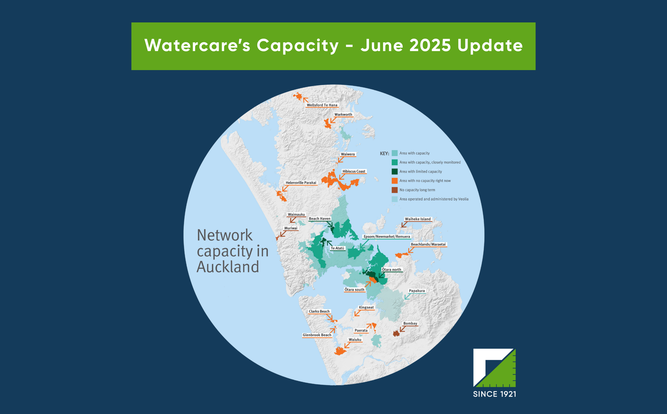
The June 2025 version of the map separates the different water and wastewater layers into five categories that are now easier to understand. Watercare states this shift is about transparency and early warning, aiming to flag pressure points well before a “no capacity” sign goes up. Other changes and improvements include:
- Simpler, Area-Based Labels: The revised maps now show the overall status of each area, rather than separating water and wastewater limitations. This makes it easier for developers to understand the situation at a glance and reduces misinterpretation about what “limited” actually means.
- Enhanced Data and Targeted Monitoring: Watercare has incorporated more detailed analysis of network performance, especially the frequency of wastewater overflows, to refine which areas require closer scrutiny. This ensures controls are targeted and environmental risks are better managed. Watercare’s analysts specifically “dived deeper into overflow data to tighten the thresholds that decide when an area moves from green to amber or red”. “Regular overflows” are defined as more than two events per location per year on average, though impact and public health risk are also considered.
- New “Closely Monitored” Zones: Four areas—Glendowie, Ōtāhuhu, East Tamaki/Flat Bush, and Epsom/Newmarket/Remuera—are now highlighted as under close watch. While these zones generally have sufficient bulk infrastructure, they are experiencing more frequent overflows or could face water supply constraints in the future. Larger developments in these zones may face more rigorous assessment at the resource consent stage.
- Improved Communication and Guidance: Watercare has updated its website with clearer explanations and a more user-friendly map interface. Developers are encouraged to consult the online tool and GIS maps for project-specific information, and to engage early in the planning process. Watercare also has an online “Water and wastewater network capacity checker”, and provides contact via email at networkcapacity@water.co.nz, or by phone at 09 442 2222 (Option 3 for works over queries, Option 4 for building and development queries).
- Ongoing Infrastructure Investment: The update reinforces Watercare’s commitment to a $13.8 billion, ten-year infrastructure programme, with more than half dedicated to supporting growth. This investment pipeline is aligned with Auckland Council’s Future Development Strategy.
Watercare Webinar – Key Takeaways
Watercare held a webinar for Auckland developers on 26 June, discussing the refreshed map and what it means for developers. Some key takeaways from this include:
- Works over delays: Watercare has addressed the Works Over backlog by adding staff, with average turnaround now four weeks and falling.
- Council alignment: Auckland Council’s GeoMaps system now contains the Watercare Capacity Constrains Area layer, meaning that you now don’t have to check both mapping systems.
- Private-sector input: Watercare has invited industry feedback on staging, construction methodology, and traffic management for Beach Haven, Ōtara-Papatoetoe, and Wellsford .
- Minor dwellings: Watercare and Auckland Council are designing a process to capture additional connections when they will use existing laterals and might not have been reviewed by Watercare previous.
- Hibiscus Coast: The Hibiscus Coast was a particular focus during the webinar. While the Army Bay treatment plant still has physical capacity, the number of resource-consented lots on the Hibiscus Coast already exceeds that capacity. In November, Watercare estimated room for roughly 4,000 extra homes, with 300 already connected. The Council is not granting new resource consents that rely on the public wastewater network until the main upgrade is complete, and the full upgrade has shifted from a 2026 to a 2031 completion.
Moving Forward
The June 2025 update reflects Watercare’s ongoing effort to balance Auckland’s rapid growth with the realities of infrastructure capacity—providing the clarity and foresight developers need to plan with confidence. The key points from the update are:
- Initial maps (Nov 2024): Highlighted separate water/wastewater constraints, causing confusion and misinterpretation.
- June 2025 update: Presents clearer, area-based status, introduces targeted monitoring, and enhances communication.
- Most of Auckland remains open for growth, but developers must pay closer attention to the newly identified “closely monitored” zones.
- Watercare is investing heavily in network upgrades and is committed to regular updates and industry engagement.
Whilst the June 2025 update is welcomed by the Auckland’s development community, the message from our March 2025 remains the same—the constrain are not insurmountable in all locations with early engagement of qualified civil engineers and planners, and Watercare critical to any development project.